Category:Roads in Thornton Curtis
Jump to navigation
Jump to search

Subcategories
This category has the following 2 subcategories, out of 2 total.
S
T
Media in category "Roads in Thornton Curtis"
The following 9 files are in this category, out of 9 total.
 Approaching Burnham Crossroads - geograph.org.uk - 1005006.jpg 640 × 481; 129 KB
 Caistor Road towards Barton Upon Humber - geograph.org.uk - 1806445.jpg 1,000 × 750; 723 KB
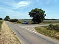 Junction at Spot Height 56m - geograph.org.uk - 194396.jpg 640 × 480; 115 KB
 Near Burnham - geograph.org.uk - 116803.jpg 640 × 480; 96 KB
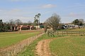
 Near Burnham Beeches Farm - geograph.org.uk - 290802.jpg 640 × 480; 97 KB
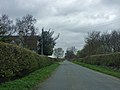
 Near Burnham Beeches Farm - geograph.org.uk - 359063.jpg 640 × 480; 123 KB
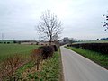
 Near Burnham Beeches Farm - geograph.org.uk - 366906.jpg 640 × 444; 102 KB
 Road Flooded near College Farm - geograph.org.uk - 483455.jpg 640 × 430; 117 KB
 The Northfield Lane Junction - geograph.org.uk - 767345.jpg 630 × 640; 97 KB