File:Frankfurt Am Main-Stadtpanorama von der Ignatz-Bubis-Bruecke am Mittag-20100424.jpg
Jump to navigation
Jump to search


Size of this preview: 800 × 281 pixels. Other resolutions: 320 × 113 pixels | 640 × 225 pixels | 1,024 × 360 pixels | 1,280 × 450 pixels | 2,560 × 900 pixels | 12,800 × 4,500 pixels.
Original file (12,800 × 4,500 pixels, file size: 18.78 MB, MIME type: image/jpeg)
Captions
Add a one-line explanation of what this file represents
Captions
| Description |
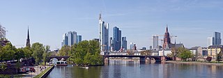
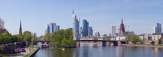
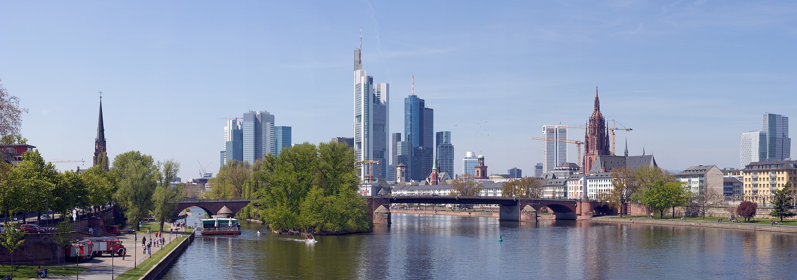
Deutsch: Frankfurt am Main: Stadtpanorama mit Alter Brücke, Dom und Skyline von der Ignatz-Bubis-Brücke am Mittag.
English: Frankfurt on the Main: Panorama of the city with the Alte Bruecke (Old Bridge), the Cathedral and the skyline as seen from the Ignatz-Bubis-Bruecke (Ignatz Bubis Bridge) at noon
Français : Vue panoramique sur la ville de Francfort, montrant le Alte Bruecke (Vieux Pont), la cathédrale et le skyline, prise depuis l'Ignatz-Bubis-Bruecke (Pont Ignatz Bubis) à midi. |
| Date | |
| Source | Own work |
| Author | Mylius |
|
| Camera location | | View this and other nearby images on: OpenStreetMap |
|---|
Licensing[edit]
English: I, Roland Meinecke (Roland Meinecke) am the creator of this work and I hereby publish it under the licences detailed below.
You may use this work free of charge under two conditions: Naming the image's author and inheritance of the chosen license. If you want to learn more details about the usage of this work, please visit my userpage. Deutsch: Ich, Roland Meinecke (Roland Meinecke) bin der Autor dieses Bildwerkes, und ich veröffentliche es hiermit unter den unten beschriebenen Lizenzen.
Sie dürfen dieses Bild unter folgenden Bedingungen kostenlos nutzen: Namensangabe des Bildautors und Weitervererbung der gewählten Lizenz. Bitte schauen Sie auf meine Benutzerseite, wenn Sie Einzelheiten über die Nutzung dieses Bildwerkes erfahren wollen. | ||||||||||
|

File history
Click on a date/time to view the file as it appeared at that time.
| Date/Time | Thumbnail | Dimensions | User | Comment | |
|---|---|---|---|---|---|
| current | 21:39, 7 June 2010 | 12,800 × 4,500 (18.78 MB) | Mylius (talk | contribs) | {{Information |Description={{en|1=Frankfurt am Main: Stadtpanorama mit ''Alter Brücke'', Dom und Skyline von der ''Ignatz-Bubis-Brücke'' am Mittag}} {{de|1=Frankfurt on the Main: Panorama of the city with the ''Alte Bruecke'' (Old Bridge), the Cathedral |
You cannot overwrite this file.
File usage on Commons
The following 25 pages use this file:
- User:Bennylin/Cityscapes
- User:Mylius/Panoramic photographs taken by me/2010
- User:PierreSelim/GFDL-1.2-Featured pictures on Wikimedia Commons
- User talk:Mylius
- Commons:Featured picture candidates/File:Frankfurt Am Main-Stadtpanorama von der Ignatz-Bubis-Bruecke am Mittag-20100424.jpg
- Commons:Featured picture candidates/Log/June 2010
- Commons:Featured pictures/Places/Architecture/Cityscapes
- Commons:Featured pictures/Places/Panoramas
- Commons:Featured pictures/chronological/2010-A
- Commons:Picture of the Year/2010/Galleries/2010-A
- Commons:Picture of the Year/2010/Galleries/All
- Commons:Picture of the Year/2010/Galleries/Index/8
- Commons:Picture of the Year/2010/Galleries/Index/Panoramas
- Commons:Picture of the Year/2010/Galleries/Panoramas
- Commons:Picture of the Year/2010/Galleries/Panoramas/Large
- Commons:Picture of the Year/2010/Galleries/Panoramas/Small
- Commons:Picture of the Year/2010/Galleries/Table
- Commons:Picture of the Year/2010/Galleries/Table/06
- Commons:Picture of the Year/2010/R1/File:Frankfurt Am Main-Stadtpanorama von der Ignatz-Bubis-Bruecke am Mittag-20100424.jpg
- Commons:Picture of the Year/2010/Results/R1/ALL/Table
- Commons:Picture of the Year/2010/Results/R1/Panoramas
- Commons:Picture of the Year/2010/Results/R1/Panoramas/Table
- Commons:Picture of the day/Unused featured pictures
- Commons talk:Picture of the Year/2010/Galleries/Table
- Commons talk:Picture of the Year/2010/Results/R1/ALL/Table
File usage on other wikis
The following other wikis use this file:
- Usage on fa.wikipedia.org
- Usage on pl.wikipedia.org
- Usage on vi.wikipedia.org