File:Schwarzenfels, Sinntal.jpg
Jump to navigation
Jump to search


Size of this preview: 800 × 251 pixels. Other resolutions: 320 × 100 pixels | 640 × 201 pixels | 1,024 × 321 pixels | 1,280 × 402 pixels | 6,000 × 1,883 pixels.
Original file (6,000 × 1,883 pixels, file size: 2.9 MB, MIME type: image/jpeg)
Captions
Add a one-line explanation of what this file represents
Captions
|
Summary[edit]
| Description |
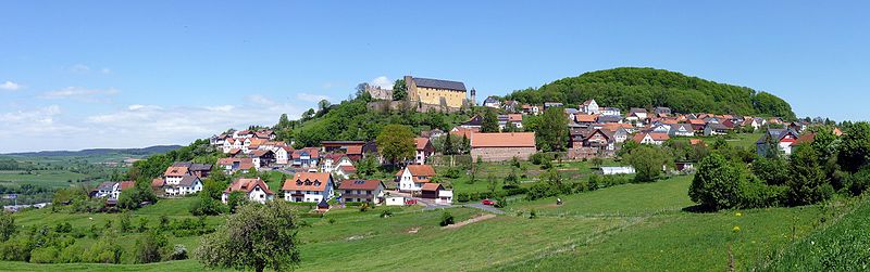
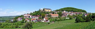
Deutsch: Schwarzenfels, ein Ortsteil in der Gemeinde Sinntal, liegt im Main-Kinzig-Kreis in Hessen, in der Nähe der Grenze zu Bayern. Der Ort liegt in etwa 400 Meter über Normalnull an einem Hang, 150 Meter über dem Sinntal. Überragt wird der Ort von der ab 1280 erbauten Burg Schwarzenfels, die seit dem 19. Jahrhundert Ruine ist.
English: Schwarzenfels, a village in the municipality of Sinntal, is located in the Main-Kinzig-Kreis in Hessen, near the border with Bayern. The village is about 400 metres above sea level on a slope, 150 metres above the Sinntal. The village is dominated by the Schwarzenfels castle, built from 1280 but in ruins since the 19th century.
Français : Schwarzenfels, un village de la municipalité de Sinntal (Arrondissement de Main-Kinzig), dans le Land de Hesse, en Allemagne. Le village se trouve près de la frontière entre la Hesse et la Bavière, à 400 m d'altitude, et 150 m au dessus de la Sinntal. Il est dominé par le château de Schwarzenfels, bâti en 1280 et en ruines depuis le XIXe siècle. |
| Date | |
| Source | Own work |
| Author | Rainer Lippert |
| Camera location | | View this and other nearby images on: OpenStreetMap |
|---|
![]() This image was created with Hugin.
This image was created with Hugin.
Licensing[edit]
| I, the copyright holder of this work, release this work into the public domain. This applies worldwide. In some countries this may not be legally possible; if so: I grant anyone the right to use this work for any purpose, without any conditions, unless such conditions are required by law. |
File history
Click on a date/time to view the file as it appeared at that time.
| Date/Time | Thumbnail | Dimensions | User | Comment | |
|---|---|---|---|---|---|
| current | 17:08, 27 May 2010 | 6,000 × 1,883 (2.9 MB) | Rainer Lippert (talk | contribs) | EXIF ergänzt | |
| 19:56, 25 May 2010 | 6,000 × 1,883 (2.88 MB) | Rainer Lippert (talk | contribs) | ü. | ||
| 19:09, 25 May 2010 | 6,000 × 1,883 (2.19 MB) | Rainer Lippert (talk | contribs) | {{Information |Description=Schwarzenfels |Source={{own}} |Date=22.05.2010 |Author=Rainer Lippert |Permission= |other_versions= }} |
You cannot overwrite this file.
File usage on Commons
The following 24 pages use this file:
- Featured Pictures in the Public Domain
- User:Bennylin/Cityscapes
- User:Ö/Best/2010
- Commons:Featured picture candidates/File:Schwarzenfels, Sinntal.jpg
- Commons:Featured picture candidates/Log/June 2010
- Commons:Featured pictures/Places/Architecture/Cityscapes
- Commons:Featured pictures/Places/Panoramas
- Commons:Featured pictures/chronological/2010-A
- Commons:Picture of the Year/2010/Galleries/2010-A
- Commons:Picture of the Year/2010/Galleries/All
- Commons:Picture of the Year/2010/Galleries/Index/8
- Commons:Picture of the Year/2010/Galleries/Index/Panoramas
- Commons:Picture of the Year/2010/Galleries/Panoramas
- Commons:Picture of the Year/2010/Galleries/Panoramas/Large
- Commons:Picture of the Year/2010/Galleries/Panoramas/Small
- Commons:Picture of the Year/2010/Galleries/Table
- Commons:Picture of the Year/2010/Galleries/Table/06
- Commons:Picture of the Year/2010/R1/File:Schwarzenfels, Sinntal.jpg
- Commons:Picture of the Year/2010/Results/R1/ALL/Table
- Commons:Picture of the Year/2010/Results/R1/Panoramas
- Commons:Picture of the Year/2010/Results/R1/Panoramas/Table
- Commons talk:Picture of the Year/2010/Galleries/Table
- Commons talk:Picture of the Year/2010/Results/R1/ALL/Table
- Category:Sinntal
File usage on other wikis
The following other wikis use this file:
- Usage on ar.wikipedia.org
- Usage on ceb.wikipedia.org
- Usage on ce.wikipedia.org
- Usage on de.wikipedia.org
- Benutzer:Rainer Lippert
- Benutzer:Rainer Lippert/Bilder
- Burg Schwarzenfels
- Wikipedia:Exzellente Bilder/Landschaften
- Wikipedia:Diskussionen über Bilder/Archiv/2010/Mai
- Wikipedia:Kandidaten für exzellente Bilder/Archiv2010/7
- Datei:Schwarzenfels, Sinntal.jpg
- Liste von Städten und Gemeinden in der Rhön
- Wikipedia:Kandidaten für exzellente Bilder/Archiv2016/4
- Benutzer:Holger1959/HE-MKK
- Usage on de.wikivoyage.org
- Usage on en.wikipedia.org
- Usage on es.wikipedia.org
- Usage on eu.wikipedia.org
- Usage on fa.wikipedia.org
- Usage on fr.wikipedia.org
- Usage on hu.wikipedia.org
- Usage on it.wikipedia.org
- Usage on mg.wikipedia.org
- Usage on pl.wikipedia.org
- Usage on pl.wikivoyage.org
- Usage on pt.wikipedia.org
- Usage on ro.wikipedia.org
- Usage on ru.wikipedia.org
- Usage on sr.wikipedia.org
- Usage on sv.wikipedia.org
- Usage on tt.wikipedia.org
- Usage on uk.wikipedia.org
- Usage on uz.wikipedia.org
- Usage on vi.wikipedia.org
- Usage on www.wikidata.org