
Equipped with state-of-the-art laboratories that provide students with hands-on experiences to bridge theory and practice
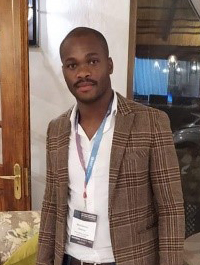
This young aspiring researcher has recently assumed the position as the Geographical Information Systems (GIS) and Remote Sensing (RS) section editor for the South African Journal of Geomatics (SAJG). The SAJG publishes peer-reviewed original papers within the broad discipline of Geomatics. This includes, inter alia, geographical information systems (GIS), remote sensing (RS), land tenure, geomatics (surveying), mine surveying and development planning. The journal focuses mainly on issues within the South African and African context, but it is not limited to this area. His role as a section editor entails assigning reviewers to articles, following up on progress, and recording and communicating decisions to authors.
Madodomzi is a lecturer in the Department of Geography in the College of Agriculture and Environmental Sciences. He is involved in the teaching of two second-year modules, namely Geography of Services Provision and The Interpretation of Maps, Aerial Photographs and Satellite Imagery. Particularly, he reviews, revises and develops module content with the aim of infusing GIS, while using examples in the African context. Moreover, he is involved in the supervision of honours students in the field of geoinformatics, while also co-supervising master’s degree students who use GIS and RS as tools to overcome environmental issues, such as invasive alien species (IAPs) and/or threatened plants.
Madodomzi holds an MSc in Geoinformatics from the University of Pretoria and is currently pursuing a PhD degree in a similar field. His research interests include GIS and RS and topics such as deep learning, machine learning and image classification techniques. He is also interested in machine learning algorithms, such as support vector machines, random forests and convolutional neural network (CNN) devices. Applications of GIS and RS for vegetation monitoring are his forte, and he is currently using CNNs and DESIS hyperspectral data to map IAPs as part of his PhD research. Furthermore, he has been involved in biomass estimation projects, both for grass and tree species, using 3D light detection and ranging (LiDAR) remote sensing. He is registered with the South African Council for Geomatics (SAGC, previously PLATO) as a Candidate GISc Professional. To date, he has published two articles and has one under review.
When asked to share his views on the achievement of being a section editor for the SAJG and its significance for his career as an emerging young scientist, Madodomzi responded: “The section editorship for the GIS and RS portfolio of the SAJG will keep me informed of the trends and research efforts in GIS and RS, which will be of more importance on my continued professional development in general. Moreover, the editorship will help with the betterment of my research skills as a GIS and RS specialist in South Africa and Africa at large”.
*by: Radingoana Pabalelo, Catharina Lotz and Sindie Kuhlase
Department of Geography
University of South Africa
Publish date: 2021/04/29
 Unisa celebrates a project of hope, dignity and student success
 Women vocalists take top honours at Unisa's globally renowned showcase
 African wealth is dependent on investment in education and development
 Unisa celebrates matric result success at Correctional Services ceremony
 Unisa ICT Director recognised among acclaimed IT leaders